I would like to know why there's a difference·between souce data and data presented in
"Longitude" and Latitude" fields. Which parameters and from sentence are used to get a correct readings?
Thanks,
PVJohn
Some of our work sites require the 1pps gps pulse but we also use the gps to transmit the site lat/long in order to have a complete message....blah blah
Anyhow, when the system has been reset, it has to rebuild it's almanac...
so it'll start by acquiring the proper amount of sats and will then determine it's position....it's never right at first. It has to do some calculations to lower the error.
So in essence, I guess you could imagine it as an average reading....and that if you left it long enough they should eventually jive.
Of course, the other thing it might be is the raw gps message (under GPGGA) gives you DDMM.mmmm where DD is 2 digits degrees and MM.mmmm is minutes to the 4 decimal place.
And your GPS program might not be using minutes but just degrees with decimal places.
Here's a cool site that will convert Decimal degrees TO DEgrees/minutes/seconds.
(A note...Northern Hemisphere latitudes are entered as positive values and Western Hemisphere longitudes are entered with a '-' sign in front of them.)
Steve "Inside each and every one of us is our one, true authentic swing. Something we was born with. Something that's ours and ours alone. Something that can't be learned... something that's got to be remembered."
I'm using HOLUX GR-213 GPS and I like it. It works even indoor, ~ 1.5 m far from·a window. http://www.holux.com.tw/Temp%20web/GR-213.html. When I use Microsoft Streets and Trips it can pin point my location without problems. The other software is free and it can be downloaded from http://www.commlinx.com.au/gps_diag.htm. I'll try a llinks that you suggested. Thanks for your help.

 PVJohn
Posts: 60
PVJohn
Posts: 60

Comments
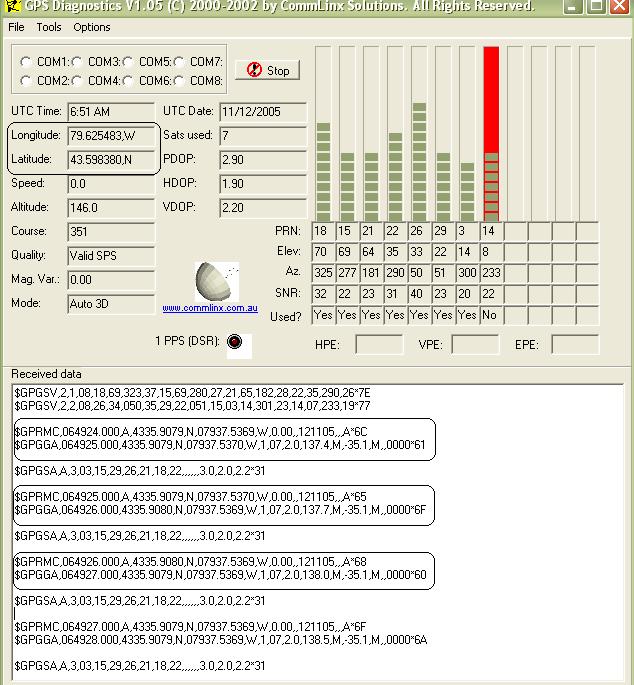
Longitude: 79.625657,W
Latitude: 43.598435,N
Source sentences:
$GPGGA,073136.000,4335.9101,N,07937.5412,W,1,07,1.3,148.5,M,-35.1,M,,0000*69
$GPGSA,A,3,21,15,14,18,22,26,29,,,,,,2.0,1.3,1.4*33
$GPRMC,073136.000,A,4335.9101,N,07937.5412,W,0.00,351.24,121105,,,A*7B
$GPGGA,073137.000,4335.9102,N,07937.5413,W,1,07,1.3,148.0,M,-35.1,M,,0000*6F
$GPGSA,A,3,21,15,14,18,22,26,29,,,,,,2.0,1.3,1.4*33
$GPRMC,073137.000,A,4335.9102,N,07937.5413,W,0.00,351.24,121105,,,A*78
$GPGGA,073138.000,4335.9103,N,07937.5415,W,1,07,1.3,147.8,M,-35.1,M,,0000*60
$GPGSA,A,3,21,15,14,18,22,26,29,,,,,,2.0,1.3,1.4*33
$GPRMC,073138.000,A,4335.9103,N,07937.5415,W,0.00,351.24,121105,,,A*70
$GPGGA,073139.000,4335.9103,N,07937.5418,W,1,07,1.3,147.1,M,-35.1,M,,0000*65
$GPGSA,A,3,21,15,14,18,22,26,29,,,,,,2.0,1.3,1.4*33
$GPGSV,3,1,09,18,77,032,39,15,67,221,30,22,50,302,25,21,44,176,27*72
$GPGSV,3,2,09,14,23,244,18,26,17,056,23,03,10,284,,19,09,317,*76
$GPGSV,3,3,09,29,07,058,16*46
$GPRMC,073139.000,A,4335.9103,N,07937.5418,W,0.00,351.24,121105,,,A*7C
$GPGGA,073140.000,4335.9104,N,07937.5422,W,1,07,1.3,146.3,M,-35.1,M,,0000*66
$GPGSA,A,3,21,15,14,18,22,26,29,,,,,,2.0,1.3,1.4*33
$GPRMC,073140.000,A,4335.9104,N,07937.5422,W,0.00,351.24,121105,,,A*7C
$GPGGA,073141.000,4335.9105,N,07937.5424,W,1,07,1.3,145.3,M,-35.1,M,,0000*63
$GPGSA,A,3,21,15,14,18,22,26,29,,,,,,2.0,1.3,1.4*33
$GPRMC,073141.000,A,4335.9105,N,07937.5424,W,0.00,351.24,121105,,,A*7A
$GPGGA,073142.000,4335.9105,N,07937.5427,W,1,07,1.3,144.6,M,-35.1,M,,0000*67
$GPGSV,3,2,09,14,23,244,18,26,16,056,23,03,10,283,14,19,09,317,*75
$GPGSV,3,3,09,29,07,058,16*46
$GPRMC,073154.000,A,4335.9074,N,07937.5412,W,0.00,351.24,121105,,,A*7C
$GPGGA,073155.000,4335.9071,N,07937.5406,W,1,07,1.3,142.7,M,-35.1,M,,0000*67
Some of our work sites require the 1pps gps pulse but we also use the gps to transmit the site lat/long in order to have a complete message....blah blah
Anyhow, when the system has been reset, it has to rebuild it's almanac...
so it'll start by acquiring the proper amount of sats and will then determine it's position....it's never right at first. It has to do some calculations to lower the error.
So in essence, I guess you could imagine it as an average reading....and that if you left it long enough they should eventually jive.
Of course, the other thing it might be is the raw gps message (under GPGGA) gives you DDMM.mmmm where DD is 2 digits degrees and MM.mmmm is minutes to the 4 decimal place.
And your GPS program might not be using minutes but just degrees with decimal places.
Here's a cool site that will convert Decimal degrees TO DEgrees/minutes/seconds.
(A note...Northern Hemisphere latitudes are entered as positive values and Western Hemisphere longitudes are entered with a '-' sign in front of them.)
I put your numbers in and they didn't quite jive to what I thought....but it still is a neat site!www.geology.enr.state.nc.us/gis/latlon.html
▔▔▔▔▔▔▔▔▔▔▔▔▔▔▔▔▔▔▔▔▔▔▔▔
·
Steve
"Inside each and every one of us is our one, true authentic swing. Something we was born with. Something that's ours and ours alone. Something that can't be learned... something that's got to be remembered."
Looking at the screen shot it looks like the program is outputting the cordnances in:
Degrees.degrees
The NMEA output of your receiver is:
Degrees Minutes.minutes
My conversions don't exactly match your programs output, maybe your program is averaging the values.
Mike
▔▔▔▔▔▔▔▔▔▔▔▔▔▔▔▔▔▔▔▔▔▔▔▔
"OEM NMEA GPS Module" Now available on ebay for only $19.99
Product web site: http://www.allsurplus.net/Axiom/
Post Edited (Mike Cook) : 11/12/2005 7:41:56 PM GMT
I'm using HOLUX GR-213 GPS and I like it. It works even indoor, ~ 1.5 m far from·a window. http://www.holux.com.tw/Temp%20web/GR-213.html. When I use Microsoft Streets and Trips it can pin point my location without problems. The other software is free and it can be downloaded from http://www.commlinx.com.au/gps_diag.htm. I'll try a llinks that you suggested. Thanks for your help.
PVJohn